Scientists work with farmers to find ways to reduce surface runoff and soil erosion, thereby also reducing water pollution Dr. Mae-Wan Ho
A team of scientists and local farmers used a computer simulation programme to help identify the best ways to reduce surface runoffs and soil erosion on farms [1].
The study was done in collaboration with the local authorities in an area of south-western France that suffers badly from surface runoffs and soil erosion after rainfall.
To support the work, they used a geographic information system (GIS) computer simulation model of water flow and soil erosion, STREAM, to assess the impacts of a spring stormy event under different management scenarios at two sites chosen by the farmers. The results were jointly analysed and evaluated by the farmers and scientists, and the farmers discussed the technical and economic feasibility of each management scenario.
The STREAM simulations showed that a 40 mm spring rainfall with current cropping patterns led to 3 116 m3 total water runoff and 335 tonnes of sediment at site A, and 3 249 m3 water runoff and 241 tonnes of sediment at site B. Growing grass strips at strategic places could reduce runoff by about 40 % and sediment by about 50 % at site A. At site B, grass strips could reduce runoff and sediment by more 50 %, but changing the cropping system could eliminate both runoff and sediment almost entirely.
Agriculture is a major user and polluter of water, and this needs urgent attention in view of the global depletion of fresh water resources (see [2, 3] World Water Supply in Jeopardy, SiS 56; Using Water Sustainably, SiS 57).
The problem started from the 1960s when intensive agriculture was introduced in Europe to increase crops yields (see [1]). This required mechanisation and the application of fertilizers and pesticides, which soon favoured big farms at the expense of small farmers. And the now well-known environmental problems of runoff, soil erosion and pollution of water resources started to emerge.
Over the past 20 years, groundwater and surface water monitoring in Europe revealed significant nitrate and pesticide contamination, especially in France, where surface water samples often exceed the drinking water limit of 0.1 mg pesticides/L. For example, 96 % of surface water in the Department Tarn and Garonne in south-western France was contaminated by nitrates, phosphorus and pesticides, partly because of erosive runoff in cultivated fields.
In 2000, the European Community introduced the Water Framework Directive (WFD) to restore and preserve the quality of all water resources. It set targets of water quality to be achieved by 2015. The common agricultural policy (CAP) reform of 2003 introduced the ‘cross-compliance principle’ that linked the full payment of CAP aids to farms to compliance with agri-environmental standards called “good agricultural and environment condition”, which include a part of the annual cropped area to have permanent plant cover to prevent soil erosion and buffer strips (no-cultivated or grass planted) along water courses to prevent surface water pollution.
According to French decree, the total surface area of permanent plant cover (PPC) in each farm must be at least 3 % of the annual cropped area. PPC or grass strips must be planted within fields, most importantly, those bordering rivers, and the strips must be between 5 and 10 m wide and must cover at least 500 m2. Designing these agri-environmental measures (AEM) is not a trivial matter, and will differ for farms at catchment level as opposed to river level. Therefore modelling could help find the best design. And working with farmers in real farms would also put the model to proper test.
The study was done in the French Department Tarn et Garonne in collaboration with Lomagne district agricultural committee. Soil erosion is prevalent in these catchments and sediment loads in streams and rivers impact negatively on water quality.
The region has a humid temperate climate, with annual rainfall between 700 and 760 mm, and average daily temperatures 10 to 35 ºC. Rainfall is low to moderate in winter, and the most intense rainfall events are in spring. The soils in the region are very susceptible to surface sealing. The water table is very deep (> 10 m). The risk of erosive events is very high in April-May, when intense rainfalls occur (20-40 mm in 2 to 3 hours) and many fields have just been sown.
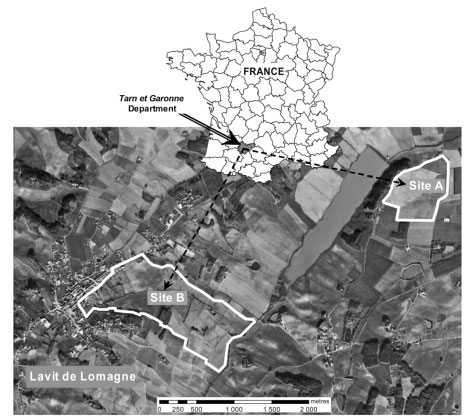
Figure 1 Sites selected for study in southern France
In collaboration with the local farmers, two sites were selected (see Figure 1). The first is a 41 ha hillside farm with slopes ranging from 0 to 15 %, comprising five large fields cultivated by two farmers. In 2009, 36 ha were planted with spring crops (maize and sunflower) and 5 ha with winter wheat. Spring storm causes mud flows in the fields with spring crops that cover the downhill road nearly every year. The second site is a 107 ha catchment that supplies the Serre River and comprises 40 fields cultivated by 5 farmers. This site is characterized by a steep-sided upstream valley with strong slopes (> 15 %), followed by a relatively flat valley (slope between 0 and 5 %). In 2009, five main crops were cultivated: winter crops (wheat, barley and rape) on 43 % of the area, spring crops (maize, sunflower and sorghum) on 41 %. Grasslands account for 12 % of the area mainly in the upper basin, while forest and set-aside account for less than 4 % of the area.
Site A was chosen because erosive runoff is severe and occurs almost every year in spring. Site B was chosen because it is small and different crops are grown there. Another important factor was that most of the farmers (5 of 6) in the two sites selected agreed to spend time with the scientists.
The software package STREAM is a geographic model of runoff and erosion at the field and event scale, developed by a company in California, USA. The basic hypothesis of the model is that soil surface properties such as soil roughness, surface crusting and vegetation cover control water runoff and soil erosion/redistribution processes in agricultural landscapes. It also takes account of tillage direction and landscape features such as ditches, hedges, roads, and developed sites.
To validate a STREAM model requires measuring runoff and sediment yield. But such figures did not exist on either site. Five meeting with farmers took place between January and June 2009. The first two meetings were with the Lomagne district agricultural committee to choose the sites. The third meeting in early May 2009 was spent by the scientists visiting the sites with most of the farmers to record cropping practices and the state of the surface soil. The fourth and fifth meetings were spent validating the simulated runoff network qualitatively, building scenarios for the two sites including alternative locations for grass strips and/or changes in cropping patterns, and analysing the simulated impacts of changes.
The STREAM model was first run with the crops and soil surface states recorded at each site during the first visit. These were used to validate the simulation models qualitatively. The farmers compared the simulated results with what they have observed in the past in terms of runoff pathways and erosion-accumulation rates. This was the baseline scenarios (A0 and B0) for comparison with simulated results of proposed changes.
The changes were suggested by analysis of the baseline scenarios: two for site A: A1 and A2; and three for site B: B1, B2 and B3. Two kinds of management options were discussed: grass strips inside or on the border of fields, or grassland fields to slow down runoff and enable water to infiltrate; and changes in cropping pattern, given that runoff and erosion on spring crops are higher than on winter crops.
For the hillside at site A, the proposal concerned the location and dimensions of grass strips: standard 5 m wide strips bordering ditches (scenario A1) or 10 m wide strips located mid-slope in the fields where slopes are steepest (scenario A2). No cropping pattern change was tested at site A because farmers did not choose to test it, but was tested at site B. In the scenario B1, a long narrow field bordering the river and standard grass strips bordering rivers and ditches were combined with existing cropping patterns. Scenario B2 involved a redistribution of spring and winter crops within the watershed combined with a long narrow field bordering the river. In scenario B3, all cropped fields were changed to winter crops.
The results of the simulations are given in Table 1. As can be seen, planting 5 m grass strips bordering ditches and roads (A1) reduced runoff by about 45 % and sediment by about 25 %. Planting 10 m grass strips where the slope was steepest (A2) reduces runoff by 43 % and sediment by 39 %. Thus A2 was better than A1; but most of the farmers did not like A2 because it reduced the size of the fields and tractors are not allowed on the strip as it would compact the soil.
Table 1 Simulated runoffs and sediments for different scenarios
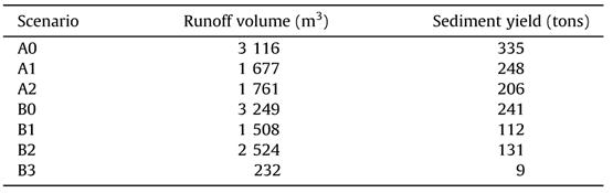
For site B, planting grass strips bordering the rivers (B1), in accordance with official regulations resulted in reduction of more than 50 % runoff and sediment. The reallocation of winter and spring crops in the catchment by putting winter crops close to the river (B2) gave a slightly lower reduction in sediment, but runoff was only reduced by 22 %. Planting only winter crops (B3) reduced runoff and sediment almost completely. However, the farmers did not agree with this cropping because it would lead to a major reduction in their income; though prices on agricultural products can strongly vary between years. In addition, farmers confirmed that alternating spring and winter crops enabled better pest and weed control.
As the results of the simulation demonstrated the major impact spring crops have on erosion, the farmers were willing to discuss the drastic solution of planting only winter crops in catchments where erosion is a very serious problem.
The study did not include change in the direction of tillage because the model had not been validated for it, and because farmers did not want to change tillage direction in sloping fields, as across-slope tillage is impossible and even dangerous when the slope exceeds 10 %. Nevertheless, it is well-known that across-slope tillage slows downhill runoff.
Seeding spring crops directly into mulch could also be an option to prevent the risk of erosion. Farmers did not choose to test this option because the topic divided the farmers in the area. Nevertheless they were willing to discuss this option after the simulation. They claimed that the option presents two major constraints: it needs high cost drilling machines and is risky in the local soil because results are very variable and unpredictable as has been found on imperfectly drained loamy soils.
Fields cultivated with spring crops are the main source of erosive runoffs. Some mayors in France have issued an order to limit spring crop acreage in their municipality and oblige farmers to come up with a collective cropping plan. A collective cropping plan is not easy, as crop history and different soil fertility have to be taken into account. Here is where a discussion involving all parties could be aided by the STREAM simulation.
Farmers’ practices are influenced by economics, and their first priority may not be to protect the environment. Thus CAP subsidies and penalties from non-compliance with AEM need to be applied to steer farmers towards environmentally beneficial choices.
The STREAM model proved useful in helping farmers, local communities and scientists to work together in order to find the best means of reducing runoff and sediment, which are crucial for replenishing underground water and improving surface water quality as well as preventing the loss of nutrient- rich top soils.
It is possible to apply the analysis on larger territories, such as entire river basins that cross national boundaries by incorporating remote sensing data. This is urgently needed not just in Europe, but worldwide [2, 3].
Article first published 11/12/12
Comments are now closed for this article
There are 2 comments on this article.
ken hargesheimer Comment left 12th December 2012 03:03:50
A computer is not needed to teach farmers how to prevent soil erosion. Use organic, no-till farming. For a free DVD, email your postal address to minifarms@gmail.com
Amit Comment left 12th December 2012 03:03:46
It's still surprising that in 2012 strategies for erosion-preventing tillage is still not well researched. This article mentions that farmers are reluctant to perform cross-tillage because of a 10% slope problem. Yet, tilling diagonally across slopes at a 45 degree angle would produce a checkerboard pattern that would not only slow runoff, but provide catchment areas for rainwater to slowly leach into the soil. The first pass down the slope would use traditional crop spacing. The second pass, at an opposite angle, would be made after seed planting every 10-15 meters apart. Using this method would eliminate the need for additional equipment, requiring only extra fuel and labor.